Our online store reopens on September 21, 2026
After a summer break, our online store will reopen on Monday, September 21, 2026.
You will once again be able to order your world maps from our website.
Thank you for your patience and your loyalty. We look forward to welcoming you back and helping you bring your projects to life.
See you soon on Original Map!
Traveling around the world from Latin America to Asia, including the Western world and the countless treasures of various countries around the globe, is what we aim to achieve by offering beautiful maps for a successful wall decoration, combining geography and decoration. Precise, up-to-date and in English, from small to Extra Large formats, in several formats, our world maps are suitable for all types of interiors, from contemporary, classic, industrial, retro, etc. Full of river names, countries, capitals, borders, islands, seas, oceans, volcanoes…: our boards are intelligent decorative objects!
On a high-quality, washable, adhesive PVC backing, with a satin finish.
We offer to the “Do It Yourself” enthusiasts the possibility to create their own “floating effect” board. Installation is easy thanks to our recommendations for use and a video to be found in our usage instructions.
Bright colours, subtle reflections, frameless… boards on Plexiglas® provide a modern twist to an interior.
In order to ease the installation of your decorative board, we offer several mounting methods. You can find our fixing system without holes or screws in our accessories.
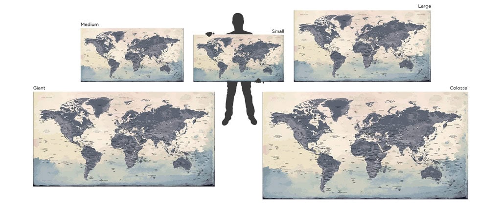
Size: Small (130x65cm) | Medium (150x75cm) | Large (200x100cm) | Giant (260x130cm) | Colossal (300x150cm)

Size: Small (130x65cm) | Medium (150x75cm) | Large (200x100cm) | Giant (260x130cm) | Colossal (300x150cm)

Size: Small (130x65cm) | Medium (150x75cm) | Large (200x100cm) | Giant (260x130cm) | Colossal (300x150cm)

Our world maps with watercolour effect are perfect for paint lovers. Offer yourself a beautiful, timeless and universal gift for all occasions.
Size: Small (130x65cm) | Medium (150x75cm) | Large (200x100cm) | Giant (260x130cm) | Colossal (300x150cm)

Size: Small (130x65cm) | Medium (150x75cm) | Large (200x100cm) | Giant (260x130cm) | Colossal (300x150cm)

World maps with a clean and elegant style for a simple interior decoration. An ideal gift for a loved ones or yourself.
We have chosen to offer a more complete World Map with the Southern Continent, otherwise known as the White Continent. Almost fully covered in ice, it is the only continent without human habitat, but many scientific bases of all nationalities have settled there. Discover these bases with our Complete World Map, as well as the many ice floes of the coldest continent on earth.
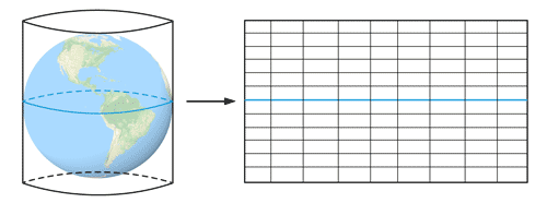
Imagined for the first time in the 19th century, Gall-Peters’ projection, so called Peters’ projection , has the advantage to represent our world in a more realistic way and keeping the real proportions between the continent sizes, wich is lacking in the Mercator Map. Because of the deformations this last mapping projection wich is the most commonly used, shows larger lands close to the North and South poles. That’s why Africa as we know it apears larger in reality.
Designed in 1921 by Oswald Winkel, the Winkel Tripel projection is a compromise between the Gall-Peters and Mercator projections: it limits both the distortions of relative surfaces and those of length and distance. It has been used since 1998 by the National Geographic Society.
Size: Small (130x65cm) | Medium (150x75cm) | Large (200x100cm) | Giant (260x130cm)

A blank world map to awaken your imagination and awaken the memories of your travels. Colour, paste, write, lay strass, trace your journeys around the globe, all choices are possible.
Small 130x65cm (~ 50″x25″) | Medium 150x75cm (~ 60″x30″) | Large 200x100cm (~ 80″x40″) | Giant 260x130cm (~ 100″x50″) | Colossal 300x150cm (~ 120″x60″)
Go on a road trip to North America, the continent of the United States, with our maps full of information. From national parks to remarkable sites, it is in a unique way that this continent belonging to the “New World” and bordered by the two largest oceans of our planet, will reveal itself to you.
Decorate your interior with a european map in several styles, sizes and materials. Thanks to it, travel from one European city to another and discover a selection of the most beautiful national parks of the “Old Continent”.
Size: Small (130x65cm) | Medium (150x75cm) | Large (200x100cm) | Giant (260x130cm) | Colossal (300x150cm)

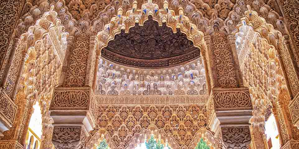
To create each World Map, Original Map drew inspiration from the world’s most beautiful wonders.
Explore these places on our page: TRAVEL WITH OUR WORLD MAPS


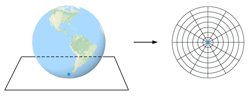
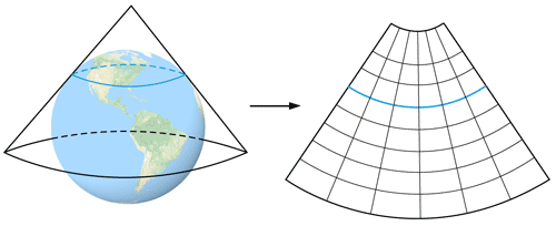
Map projections are methods used to represent the Earth’s spherical surface on a flat plane. Each projection has advantages and disadvantages depending on its intended use.
Explore projections, their history, and the navigators who used them on our page: THE WORLD OF MAPS
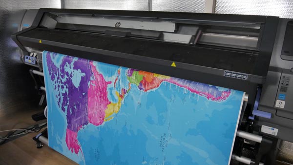
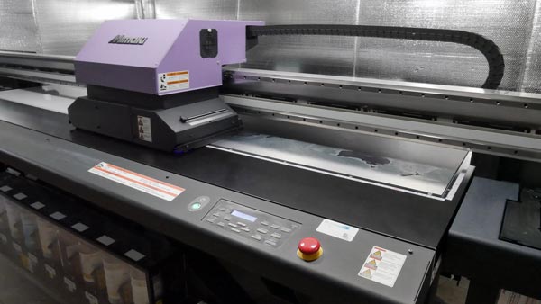
We chose to produce our maps made to order, so we can offer you a wide selection of projections, designs, materials and sizes.
This approach also helps us avoid waste and ensures every map is fully up to date at the time it is made.
With 8 years of experience, we’ve designed sturdy packaging — incidents are rare.
If a problem does occur, simply send us a few photos and we will quickly launch a reprint.
📦 For smoother delivery, please include your mobile phone number when ordering. You’ll then receive SMS tracking and — if needed — be able to choose collection at a parcel point.
You can also find our high-end collection.
Return to the Homepage.

< Secure payment >